Gila Bend Mountains, Arizona

Introduction

The Gila River flows south from Buckeye, then makes a wide turn to the west towards Yuma and its juncture with the Colorado River. The Gila Bend Mountains lie to the northwest of this bend in the river while the town Gila Bend lies to the southeast. Rugged, rocky, very dry, and low-elevation hills and mountains have until recently been mostly neglected by outdoors recreationists. There are scattered and abandoned mines, a few small seasonal cattle operations, and two Wilderness Areas.

The Woolsey Peak Wilderness is in the eastern end of the range while in the west end is Signal Mountain Wilderness. Between the wilderness areas are numerous jeep roads and ad hoc trails blazed by ORV's, hikers and cattle. Water is almost non-existent, although the maps show a few springs. Mesquite and Desert Willow trees suggest that some of the major washes have favorable underground water. The long gone prospectors left some treasure behind in the form of fanciful names for some of the hills: Bunyan Peak; Fourth of July Butte; Yellow Medicine; Face Mountain; Dixie Peak.

Google Terrain Map
use controls to zoom or navigate
Link Below for Large Map


View Larger Map. Area described by this page is indicated by the trekker symbol. The camp symbol points to the BLM campsite at the Painted Rock petroglyphs. Blue line follows Agua Caliente Road.
Webb Mountain as viewed from the northwest.  Photo © Mike Plagens

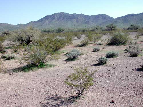
Webb Mountain, one of the middle-sized peaks in the range, as viewed from the northwest. Photographed Feb. 17, 2008.

Areas close to the Gila River bed are devoted to agriculture. There are two dams located on this stretch of river - Gillespie Dam east of the Gila Bend Mountains no longer holds back water. Painted Rock Dam on the south can sometimes create a large, shallow lake that floods large areas near the river. After drought years the lake may disappear nearly completely. The state park that once graced the lake shore is closed because the water has been contaminated by chlorinated pesticides and similar chemicals. The danger is primarily in consuming fish caught in the lake. Arizona opted to close the lake to fishing and recreational activities.

Directions

From the Phoenix area head west on I-10, then turn south on Hwy 85.

Option 1: Turn west on Hazen Rd. and proceed along Palo Verde Rd. (Old US-80) to Arlington. Just south of Arlington turn west onto Aqua Caliente Rd. This road skirts the north and west sides of the Gila Bend Mountain range finally meeting up with Sentinel on I-8 west of Gila Bend. The distance is over 60 miles and there are no services along the way. If you journey this way be prepared with water and food and make sure fuel is sufficient.

Option 2: Turn west from Hwy. 85 onto Patterson Road hitting Old US-80. From there head north on Old US-80 crossing the Gila River at Gillespie Dam. Just past the dam bridge there is a road running down along the west side of the Gila River with the Woolsey Peak to the west. There are several jeep roads and canyon walks offering access.

Sponsored Links

Birds

Commonly Encountered Species:

  1. Black-tailed Gnatcatcher -- Polioptila melanura -- S,F,W,Sp
  2. White-crowned Sparrow -- Zonotrichia leucophrys -- W,Sp
  3. Gilded Flicker -- Colaptes chrysoides -- S,F,W,Sp
  4. Costa's Hummingbird -- Calypte costae -- S,F,W,Sp
  5. Verdin -- Auriparus flaviceps -- S,F,W,Sp
  6. Common Raven -- Corvus corax -- W,Sp
  7. Brewer's Sparrow -- Spizella breweri -- W,Sp

Mammals

Only visit on February 17, 2008 ... no mammals other than domestic cattle were seen.

Cacti

In general order of Abundance:

  1. Buckhorn Cholla (Cylindropuntia acanthocarpa) -- on hills/bajadas
  2. Diamond Cholla -- Cylindropuntia ramosissima -- on desert pavement away from hills
  3. Saguaro Cactus (Cereus giganteus) --
  4. Fishhook Pincushion (Mammalaria grahamii)
  5. Hedgehog Cactus (Echinocereus engelmannii) --
  6. Compass Barrel Cactus (Ferocactus acanthodes) -- Spines tinged with red and yellow.
  7. Night-blooming Cereus (Peniocereus greggii) --
Photo by NASA

This picture is hosted at Wikimedia Commons where there are many more images of cacti.

Shrubs and Trees

In general order of Abundance:

  1. Creosote Bush (Larrea tridentata)
  2. White Bursage -- Ambrosia dumosa
  3. Foothills Palo Verde (Cercidium microphyllum) -
  4. Ironwood (Olneya tesota) - A few along drainages
  5. Desert Mistletoe (Phoradendron californicum) - Parasitic shrub growing upon various desert trees including Palo Verde and Ironwood.
  6. Graythorn -- Ziziphus obtusifolia
  7. Cat-Claw Acacia (Acacia greggiii) - mostly along the washes
  8. Wolfberry (Lycium californicum spp.) - concentrated along wash banks
  9. Blue Palo Verde -- Parkinsonia florida - in major washes only
  10. Fremont Thorn Bush -- Lycium fremontii
  11. Trangle-leaf Bursage(Ambrosia deltoidea) --
  12. White Ratany -- Krameria grayi -- purplish cast to woody stems
  13. Graythorn -- Ziziphus obtusifolia
  14. Velvet Mesquite -- Prosopis velutina - a few in major washes
  15. Crucifixion Thorn -- Castela emoryi - on deep soil areas down washes
  16. Desert Willow -- Chilopsis linearis
  17. Virgin's Bower (Clematis drummondii) -- along wash
Sponsored Links

Field Trip Report

February 17, 2008

Butterflies of Southeast Arizona

Plenty of wildflowers, but they seemed small suggesting these hills got much less rain than the foothills east and north of Phoenix. Plenty of variety, but some flowers not yet open. A night-blooming Cereus was found with two ripe fruits. This is much later than the usual ripe time of late summer reported in several references I consulted. Lycium fremontii was in bloom but not L. californicum. Desert Lilies were up all over this area, suggesting a spectacular show if they all bloomed together! Pima Orangetip (Anthocharis cethura pima) butterflies were on the wing.

Wildflowers found:

  1. golden yellow California Poppy -- Eschscholzia californica
  2. vivid blue-purple Notch-leaved Phacelia -- Phacelia crenulata
  3. Orange Fiddleneck -- Amsinckia intermedia
  4. diminutive Peppergrass -- Lepidium lasiocarpum
  5. yellow Bladderpod Mustard -- Lesquerella sp.
  6. a diminutive, white-flowered mustard: Whitlowgrass -- Draba cuneifolia
Sponsored Links

Sonoran Desert Naturalist Home Page

Desert Places

Field Guide


  Google

Copyright Michael J. Plagens, page created 06 March 2008,
updated 27 April 2018.